


As parts of the Southwest are expected to endure another day of heavy rain and flash flooding on Sunday, a developing cross-country storm could produce a soggy Election Day across the central United States.
Flood watches remain in effect on Sunday across much of Arizona, portions of southern Utah, southwestern Colorado, northwestern New Mexico and southern Nevada.
Over the weekend, parts of the Southwest have received 1 to 2 inches of rain, ramping up a flash-flooding threat.
A level 3 of 4 risk for flash flooding is forecast on Sunday across the region, including the cities of Flagstaff, Ariz., Cedar City, Utah, Durango, Colo., and Farmington, N.M. The Grand Canyon, Zion and Bryce Canyon National Parks are also at risk of flash flooding.
Cross-country storm track
The renewed flash-flood threat across the West and Southwest — including Arizona, Colorado, New Mexico and Utah — is expected to be exacerbated by a cross-country storm system that will begin hitting the West on Sunday.
The town of Pagosa Springs, Colo., was being evacuated on Sunday ahead of potentially historic flooding of the San Juan River, according to the Archuleta County Sheriff’s Office. Mandatory evacuation orders were in effect Sunday afternoon, about a week after the San Juan River spilled its banks and caused flooding in Pagosa Springs.
“The river is rising faster than originally anticipated and is now expected to crest higher than previously forecast,” the sheriff’s office said in a social media statement on Sunday.
The river, according to the sheriff’s office, could crest as soon as 6 p.m. local time on Sunday.
“Even if you are not currently in a mandatory evacuation area, we strongly encourage anyone who does not feel safe where they are to move to higher ground NOW. Do not wait until conditions worsen,” the sheriff’s office said.
Colorado Emergency Management officials said in a social media statement on Sunday that the San Juan River is expected to rise to historic levels.
“To put the forecast into perspective, during the devastating 1911 flood that wiped out most of what existed as the town of Pagosa at that time, the San Juan River crested at approximately 17.8 feet. The current forecast calls for the river to rise nearly 2 feet above that historic level.”
Across Arizona, flash flooding and numerous road closures were being reported Sunday afternoon. Evacuation orders were also issued for parts of Sedona and Cedar Creek, Ariz., due to the rapidly rising floodwaters, including along Oak Creek in the area.
Sedona Fire posted an alert on their Facebook page, saying they were “calling in extra personnel to assist with an excessive amount of rescue operations in the area.” The post included a video of homes being flooded and vehicles getting stuck in the rapidly rising waters.
White Mountain Apache Tribe, a federally recognized sovereign nation of about 15,000 members in east-central Arizona, also issued evacuation orders on Sunday afternoon.
Besides heavy rain, mountain snow is possible over the next few days across the higher elevations of the southern Sierra Nevada to central Rockies. However, it remains too early to tell how the cross-country storm will affect other parts of the country as it moves east.
The system is expected to sweep across the center of the country on Monday, bringing rainy weather to parts of the Plains and upper Midwest.
On Monday, scattered severe thunderstorms may develop across portions of the central and southern Plains by the late afternoon and evening hours. Wichita Falls, Texas, Wichita, Kan., and Oklahoma are expected to be in the threat zone.
Severe thunderstorms moving across the Plains and upper Midwest could also be accompanied by potentially damaging wind gusts, large hail and tornadoes.
Early forecast for Election Day
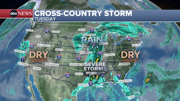
On Tuesday, Election Day, unsettled weather will be focused over the center of the country and parts of the Gulf Coast. The East and West coasts will be mostly dry for Election Day.
Rain showers on Tuesday are expected to become widespread across portions of the central Plains and Midwest, with strong thunderstorms possible from East Texas into the lower Mississippi Valley.
Rain showers will become more widespread across portions of the central Plains and Midwest,
The cross-country storm could reach the East by Wednesday and Thursday as a weakened system, with possible scattered showers and thunderstorms across the area.
Separate system impacting parts of Florida
A separate system is expected to bring an elevated flash-flood risk to eastern Florida on Sunday and Monday.
Flash flooding could develop across parts of the Florida peninsula as rounds of heavy rain sweep across the region. Flood Watches have been issued from Miami to Cape Canaveral through Monday afternoon.
Copyright © 2026, ABC Audio. All rights reserved.


